Like walking through a temple… You will find five thousand years of sacred silence waiting for you in the city of Anı.
He began by invoking the name of Allah on that great day: “I, Seljuk Sultan Alparslan, conquered the city of Anı and gave the administration of the city to the Şeddatoğulları, who are under my rule.” These proud words are legible in the Kufic inscription of the Seljuk sultan who set foot in the city in 1064. In other words, exactly four thousand sixty-four years elapsed from the arrival of the first people to appreciate the fertility of this wetland plateau and seek refuge in its hillside caves until Alparslan entered it in the 11th century. Even today the remnants of a civilization that commenced with a handful of people in the Bronze Age continue to be a final destination on the journeys of curious travelers who are willing to cover a few thousand kilometers to get there.
THE GEOGRAPHY
Immediately adjacent to the village of Ocaklı 45 kilometers from Turkey’s eastern city of Kars, the town of Anı nestles in the valley of the Arpaçay, a tributary of the Aras River in the east. The Bostanlar river borders it on the west and northwest. Situated on a plateau cleaved by valleys on three sides, the city is exposed on its south-southwest side, which is protected by thick defenses whose original load-bearing walls have collapsed today. What we are talking about here is a city protected both geologically and strategically, whose land combines fertility with security. This made it one of the most sought-after stops on the Silk Road for both travelers and conquest-hungry sultans and kings.
A PRONUNCIATION ERROR
The renowned 17th century Ottoman traveler Evliya Çelebi is said to have called it ‘the city of An’ in his Seyahatname. Appearing in Latin inscriptions as ‘ANI’ in capitals, it was later written as ‘Ani’ since there was no lowercase undotted ‘ı’ in the period when it first began appearing in western sources. Not knowing any better, those encountering it for the first time read it in this way. Undotted ‘ı’ is also used on the maps of the Provincial Directorate of Culture and Tourism, while the world-famous local guide Celil Ersözoğlu points out that the original settlers who inhabited caves in the environs until the earthquake of 1949 also called it ‘Anı’ (with an undotted ‘ı’) and that the other pronunciation is due entirely to error.
LITERATURE ON THE SUBJECT
A welter of conflicting names and dates are given in the not insignificant number of books or articles that have been written about the city. Meanwhile excavation continues in the area today and, unlike the other ancient cities in Turkey, not all of Anı’s secrets have yet been unearthed, a situation which shows first of all that a place may have more than one name when many tribes have passed through it or taken it under their rule. For every period made additions to the area according to its own needs, and called it by a new name for a certain period of time as the cycle of life continued. The name of the city dates to the first quarter of the 20th century in a scholarly study by Josef Strzygowski, the oldest work on the subject written in modern times. As the reports of the excavations being carried out today are published, more in-depth literature on the subject is being produced.
NATURAL DEVASTATION
Just like the valleys we said surround it on three sides, there are gaps in the chronological history of Anı as well, caused by earthquakes. The destruction wreaked by the attack in 1249 of the Mongols, who had overrun all of Asia and parts of Europe, was a sharp turning point. For a period of almost a hundred years from that date, the advance of civilization in the city came to a halt. The earthquakes and the ruthless Mongol invasion all coincide with the period when the city lost large numbers of people to migration and the population dwindled considerably. Its days as the ‘City of Forty Gates’ and the ‘City of 1001 Churches’ with a population of over 100,000 at the start of the 11th century had been left far behind.
STANDING ON THE BORDER
While strolling around Anı, I stop at one of the farthest outposts of Turkey I can possibly reach. I’m not just near the border, I am on the border, so close that the distance cannot be measured on any ordinary map.
I am standing almost directly on the red line visible on the map. Dynamite being exploded at a stone quarry on the ‘other side’ of the Arpaçay, in other words of the border, until about five years ago is said to have been responsible in large measure for the destruction of the city’s ancient monuments.
CITY OF TEMPLES
These ruins exhibit one characteristic immediately discernible even to a visitor with no knowledge of the city, namely, that they are the unique surviving remains of a people and culture. Something whispers to us of the possible magnitude of the civilization that flourished here: its temples.
Anı is a sacred place, adorned with monuments of religious belief that stand as a testimony to what can be accomplished through faith over the generations. There is a virtual feast of art history here, from the Zoroastrian fire-temple to Christian architectural decoration and the octagonal minareted Islamic mosque. The Manuchehr Mosque (1072) has the distinction of being the first mosque built by the Seljuks in Anatolia. Another Islamic monument is the Ebul Muammeral Mosque (Boz Minare). The (Keçeli) Church) of the Saviors (1034) still stands miraculously despite having been rent in two by lightning. The Tigran Honents Church (1215) is one of the most important buildings of the period for the ornamentation on the interior of its dome. Other important works include the Abughamrent Gregor Church (998), built by the Great King Gagik II, and the Pigeon Church (Genç Kızlar Kilisesi), the date of whose construction on steep rocks difficult to scale even today is uncertain. The best-preserved building in the city today, and a masterpiece of Armenian architecture, is the Great Cathedral (Fethiye Cami) (987-1010), which was temporarily used as a mosque after Alparslan’s conquest of the city in 1064. The Church of the Apostles (1031) meanwhile was originally built as the patriarchate and enlarged and converted into a caravanserai after the Seljuk conquest.
AN INVISIBLE HAND
Whatever flag waved from its city walls in whatever period, what we have here is a city in whose streets resounded probably all the languages of the nearby lands and seas. And what explains the diversity that was spread over an area of such breadth is something magical, the work of an invisible hand: trade. Even the ruined state of the Silk Road Bridge that separates yet actually joins the two countries quietly whispers that trade relations are not the only thing that came to an end. The quintessential orderly roads and marketplaces associated with Eastern Rome and the Seljuk caravanserais that served to ensure the safety of the Silk Road are a constant reminder of those old days, days when the city was a wealthy stop on the medieval trade route. One of the safest centers of accommodation and trade despite the wars that raged right next door, when the bad times set in Anı became a place to be avoided at all costs.
WHERE FACT AND LEGEND INTERMINGLE
Truth and rumor, history and legend have intermingled here. Time came to a standstill so long ago that it is not important today even where the sun rises and sets. Practically every scrap of information we give about Anı has to be qualified with a ‘so they say’. As I leave for home passing beneath the great gate I had quietly slipped through earlier, I know that one day some perceptive and open-minded people are going to decode the whispers among all these tablets and Kufic inscriptions. And then the past is going to speak, scattering truth over the legends that surround this sad and solitary city. I feel I’m leaving behind the only place in the world where I can find so much sadness side by side with so much tranquility. Leaving Anı behind to return again...
This article was published in Turkish Airline's inflight magazine Skylife on October 2007.
1 Ekim 2007 Pazartesi
Sadece sessiz

Beş bin yıllık kutsal tarihi sessizce beklerken Anı kentinde bulacaksınız, tıpkı bir mabed içinde yürür gibi…
Besmeleyle başlar söze o büyük günde: “Ben Selçuklu Sultanı Alparslan. Anı şehrini fethettim ve yönetimini hükümdarlığım altındaki Şeddatoğulları’na verdim…” Bunlar, 1064’de kente ayak basan sultanın kufi gizemin ardında okunabilen mağrur sözleri. Yani, bu sulak platonun bereketini görmüş ve yamaçlarındaki mağaralara sığınmaya karar vermiş ilk insanların gelişinden o güne, tam dört bin altmış dört yıl geçmiş Alparslan Anı’ya girdiğinde. İlk Bronz Çağı’nda belki bir avuç insanla başlayan medeniyet macerası, bugün en az birkaç bin kilometreyi geride bırakmayı göze alan meraklı gezginlerin seyahatlerinin son durağı olarak devam ediyor.

COĞRAFYA
Kars’a 45 kilometre mesafedeki Ocaklı Köyü’nün yanı başındaki Anı kenti, doğuda Aras Nehri’nin kollarından Arpaçay’ın vadisine dayıyor sırtını. Batı ve kuzeybatıdan Bostanlar Deresi ile sarılmış. Üç kenarı da vadilerle yarılmış bir platoda kurulu kentin açık kalan güney-güneybatı yüzü de bugün ilk destek duvarları çökük olan kalın surlarla korunuyormuş. Yani bereket ve güvenliğin aynı topraklarda bulunduğu, jeolojik ve stratejik olarak korunmakta olan bir kentten bahsediyoruz. Bu nedenle İpekyolu’nun imrendiren duraklarından biri olmuş hep, hem yolcular hem de fetih heveslisi krallar ve sultanlar için.
TELAFFUZ HATASI
Deniyor ki Evliya Çelebi de Seyahatnamesi’nde ‘An şehri’ dermiş zaten. Latince yazıtlarda büyük harfle ‘ANI’ olarak geçen isim, batı kaynaklarında yer almaya başladığı dönemde küçük ‘ı’
 olmadığı için, ‘Ani’ olarak yazılmış. Bu isimle ilk defa karşılaşanlar da başka bir bilgi olmadığı için bu şekilde okumaya başlamışlar. İl Kültür ve Turizm Müdürlüğü haritalarında da ‘ı’ kullanılırken, dünyaca ünlü yerel rehber Celil Ersözoğlu, 1949’daki depreme kadar çevre mağaralarda yaşamını sürdürmekte olan yerleşik halkın da ‘Anı’ diyor olduğunu ve diğer kullanımın tamamen bir telaffuz hatası olduğunu vurguluyor.
KAYNAKÇA
Anı üzerine yazılmış hatırı sayılır sayıda eser birbirleriyle atışırcasına farklı tarihler ve isimler veriyorlar, bölgede kazılar günümüzde de devam ediyor ve ülkemizdeki diğer antik kentlerden farklı olarak henüz
 tüm sırlar toprak altından çıkarılmış değil. Bu durum, pek çok kavmin geçiş ve hâkimiyet bölgesine girmiş olması itibarıyla, öncelikle bir yerin birden çok adı bulunması şeklinde kendini gösteriyor. Çünkü her dönem, aynı mekâna kendi ihtiyaçları doğrultusunda eklemeler yapmış ve belirli bir zaman süresince yeni bir isimle anmış. Bu bir yaşam döngüsü şeklinde sürüp gitmiş. Kentin ismi, modern zamanlarda kaleme alınmış eserlerden en eskisi olan Josef Strzygowski’nin bir akademik araştırmasıyla 20. yüzyılın ilk çeyreğine tarihleniyor. Günümüzde tamamlanan kazıların raporları yayımlandıkça, bu kaynakça gittikçe daha da derinleşiyor.
DOĞAL TAHRİBAT
Tıpkı üç tarafını sardığını söylediğimiz vadiler gibi, Anı kentinin kronolojik tarihinde de depremlerin açtığı yarıklar var. Bir keskin tahribat da tüm Asya ve Avrupa’nın bir bölümünü istila etmiş olan Moğolların 1249’daki saldırısı. Bu tarihten itibaren neredeyse yüz yıla yakın bir süre kentteki medeniyet ilerleyişi durma noktasına geliyor. Depremler ve bu acımasız istila kentin en büyük göç verdiği ve nüfusunun oldukça azaldığı dönemlere denk geliyor. 11. yüzyıl başlarında 100 bin kişiyi geçen nüfusuyla ‘Kırk Kapılı Şehir’ ve ‘1001 Kilise Şehri’ payelerini aldığı günler çok gerilerde kalıyor.
 SINIRDA OLMAK
Anı’da yürürken, Türkiye’nin en uç noktalarından birinde duruyorum. Sınıra yakın falan değilim, sıradan bir harita ölçeğinin ifade edemeyeceği kadar yakınım. Haritada gördüğünüz kırmızı çizginin tam üzerindeyim neredeyse. Deniliyor ki, yaklaşık beş yıl öncesine kadar, Arpaçay’ın yani sınırın ‘karşı yakası’ndaki taş ocağında patlatılan dinamitler de tarihi eserlerin tahribatına büyük ölçüde neden olmuş.

 MABEDLER KENTİ
Kentle ilgili herhangi bir bilgiye sahip olmayan bir ziyaretçinin bile ilk bakışta seçeceği çok önemli bir özelliği var bu harabelerin. İnsana ve kültüre ait olarak ayakta kalmayı başarmış yegâne kalıntılar olması. Burada ne boyutlarda bir medeniyetin hüküm sürmüş olabileceğini bize fısıldayan şeyler: Mabedler…
Anı, kutsal bir yer. İnanıyor olmanın, neleri gerçekleştirme gücünü verdiğini nesiller boyunca anlatmak istercesine ayakta duran inanç anıtlarıyla bezeli. Zerdüştlerin Ateşgede’sinden, Hıristiyan mimarisinin süsleme örneklerine ve sekizgen minareli İslam eserlerine, bir sanat tarihi ziyafeti var burada: Menucehr Cami (1072) Selçukluların Anadolu’da inşa ettikleri ilk cami olma özelliği taşıyor. Ebul Muammeral Cami (Boz Minare) de İslami eserlerden bir diğeri. Kurtarıcılar (Keçeli) Kilisesi (1034) yıldırım düşmesi sonucu tam yarısından yıkılmış ama mucizevi bir biçimde hâlâ ayakta. Tigran Honents Kilisesi (1215) kubbesinin iç kısmındaki süslemeleriyle döneminin önemli eserlerinden. Büyük Kral II. Gagik tarafından yaptırılmış Abughamrent Gregor Kilisesi (998) ve bugün bile çıkılması güç sarp kayalıkların üzerine kurulu yapım zamanı tam olarak bilinmeyen Güvercinli Kilise (Genç Kızlar Kilisesi) diğer önemli eserler. Büyük Katedral (Fethiye Cami) (987-1010) Alparslan’ın kenti fethi (1064) sonrasında bir süre cami olarak da kullanılmış ve bugün kentteki en iyi durumdaki eser, Armen mimarisinin başyapıtlarından. Havariler Kilisesi (1031) ise patrikhane olarak inşa edilmiş, Selçuklu fethinden sonra ilave yapıyla kervansaraya dönüştürülmüş bir yapı.
GÖRÜNMEZ EL
Surlarında hangi bayrak hangi dönem dalgalanmış olursa olsun, muhtemelen yakın denizlerin ve karaların tüm dillerinin sokaklarında yankılanmış olduğu bir kentle karşı karşıyayız. Bu kadar geniş bir tabana yayılan farklılığı açıklayan şeyse sihirli bir şey, bir görünmez el var aslında: Ticaret. İki ülkeyi birbirinden ayıran ama aslında bağlayan İpek Yolu Köprüsü’nün yıkık hali de sona eren tek şeyin ticaret ilişkisi olmadığını sessizce fısıldıyor. Doğu Roma’nın vazgeçilmez unsurlarından düzenli çarşılar ve yollar, İpekyolu’nun güvenliğini sağlamaya çalışan Selçukluların kervansarayları hep o eski günleri hatırlatıyor. Yani kentin uğrak ve zengin bir İpekyolu durağı olduğu günleri.
 Hemen yanı başındaki savaşlara rağmen zamanın en güvenli konaklama ve ticaret merkezi olan Anı, kötü günler başlayınca, etrafından dolaşılan ve uğranılmaması gereken yerlerden olmuş.
GERÇEK İLE EFSANE BİRBİRİNE KARIŞMIŞ
Söylenti ve gerçek, tarih ve efsaneler birbirine girmiş buralarda. Zaman o kadar eski bir anda durmuş ki, güneşin nereden doğduğu ve battığı bile önemli değil bugün. Anı ile ilgili olduğunu söyleyeceğimiz hemen her bilgi ‘olduğu söyleniyor’ ibaresiyle kullanılmak zorunda. Sessizce içeri süzüldüğüm büyük kapının altından evime doğru giderken, gönül gözleri açık birilerinin tüm bu yazıtlar ve kufi kitabeler arasındaki fısıltıları bir gün çözeceğini biliyorum. O zaman geçmiş, dile gelip gerçeği serpecek bu hüzünlü ve yalnız kentin söylentilerine. Bense bu kadar hüznü, bu kadar çok huzurla yan yana bulabileceğim tek yeri bıraktım arkamda, Anı’yı arkamda bıraktım tekrar gelmek üzere...
Bu gezi yazısı, THY'nin Skylife dergisi Ekim 2007 tarihli sayısında yayımlanmıştır.
1 Eylül 2007 Cumartesi
Sleeping in the clouds
The near 4000-meter high peaks of Niğde's Aladağlar Mountains offer visitors the thrill of a lifetime.
When I stop to think about it, a thrill goes through me as I realize that I have embarked on the most important mission in my life. I think, too, about how the bags that have come 90 kilometers piled randomly on the top of the minibus were handed down, one by one, all amidst great merriment. Some fifty novice mountain climbers are standing at the side of the asphalt road that ends at Demirkazık, the last village before the mountain. And I’m one of them. Things we’d contented ourselves with only hearing about until today are upon us now in all their reality. And the sharp wind and hot sun mean that these city kids, who’ve never been up this high before, are going to be in for an even bigger surprise as the altitude increases. A bit of dizziness, perhaps some slight nausea. But if we sleep up here one night, it’ll all pass. Or so we’ve heard…
TRAVELING BY MOUNTAIN TRAIN
We are waiting for the tractors, ‘mountain trains’ to us, which we’ve been told have set out from the village. Facing us is a very long and high mass that reveals, merely by the black spots that appear here and there on its sheer north walls, that it is actually made of rock. The highest peak (Demirkazık, 3756m), which we have heard reveals itself only rarely in the winter months, crowns the northern region, hidden behind a storm-woven veil, exactly as we’ve been told it would. Alaca (3588m) and Kaldı (3736 m), the stellar peaks of the southern region where we are headed, gleam brightly with the masses of unsullied snow on their sunlit southern slopes. These details remain indelible in my mind despite the passage of close to ten years and dozens of climbs made here and in other regions of Turkey. The Yıldız Technical University Mountaineering Club is about to set up its winter training camp. The air is cold, the sun is shining brightly and the village is high. As for us, we have just seen the first real mountain of our lives, and fear mingles with awe... Opposite us is the Aladağlar Range.
A CLIMBING GARDEN
A world famous national park hundreds of square kilometers in area, stretching from Niğde to Kayseri and all the way to Adana in the other direction; a ‘climbing garden’, an important plant area (IPA) and a bird watching area to boot. Although Kayseri Airport may be preferable for reaching the mountain, we must emphasize that the climbs start from the center at Niğde.
As far as mountaineers are concerned, the region can be said to be divided basically into four: North, South, Seven Lakes and Torasan. The first three are the frequently visited spots with the most popular summits and sheer walls of rock.
The Aladağlar Mountains are a vast and ecologically sensitive area where everybody can create his own adventure, from experienced mountain climbers who want to organize their own climbs to holidaymakers who want to enjoy their annual leave at the heights amidst endemic species and peace and quiet. An area famous not only for its climbs but also for its long hikes in the adjoining areas, one of the most important of which is the Trans Aladağlar hike that starts from the boundary of Niğde province and ends at Kapuzbaşı Waterfall on the Kayseri province line.
GOING AGAINST GRAVITY
Coming back here after so many years is different, of course. You go to the valleys, the gorges, the summits as if you’re returning to a friend’s home visited often over a lifetime and remembered with affection. Even if fog blankets the valleys, you can still walk, knowing but not seeing where you’re going. The initial fear of hunger and catching cold gives way to ideas of how to organize climbs sans tent and sleeping bag so as to carry less baggage. After the hiking routes that stretch horizontally for hours, planning begins of vertical routes that take you upwards against the force of gravity. Training groups of tens of persons are superseded by climbing groups of two or three loyal friends. Teams of friends who understand each other without speaking, happy to be in pursuit of the same silence, the same cold, the same peak.
APPROACHING THE MOUNTAIN
The vast landscape over which the range is spread means that you must decide first of all which valley system your route is going to take. Like the hundreds of routes descriptions of which you can find in the guidebooks at Aladağlar, there are also hundreds of routes that have never been tried, either because of technical difficulty or because they are too long. And this is why the area is known with good reason as a ‘climbing garden’.
It is common practice here for the villagers to use their tractors transport the mountaineers to the place where they are going to start their climb. This service eliminates the need for hiking on the long, hot dirt roads in summer or trudging in the harsh wind through deep snow in winter and enables the climbers to conserve their time and energy for the actual ascent. For the villagers it is a source of income, albeit small, outside their normal activities.
SHEDDING WEIGHT
When you pack in the same bag all the technical equipment that will enable you to climb safely along with the requisite gear for comfort and keeping warm, we’re talking about a load of at least 25 kilos. In other words, it is recommendable that you rent a mule, or double the time you set aside for reaching the bottom of your route. It’s for this reason that as the years passed and the routes increased in technical difficulty, people went over to smaller, lighter and, inevitably, more expensive gear. To increase speed you might even forego carrying some of these things altogether. On advanced level technical climbs sleeping bags and tents have started to head the list of things to be left at home because they are heavy and take up a lot of room.
SLEEPING AT THE SUMMIT
Waving at airplanes, the thrill of experiencing the void, hundreds of kilometers of solitude, a profound silence not felt anywhere else, the quest for inner peace, philosophizing, blackberry picking, a picnic, an annual holiday… These are just a few of the reasons for going to the mountains. Each one an adventure in itself, each one one of the biggest thrills a person can experience in which he can test his own limits. And what about sleeping? Can that be an adventure in its own right? What do you say?
Mountain climbing is a thrill that begins the minute you put down your name and join the club. Something that’s different every time you do it. With new things to see and learn each time as if for the first time. Not just an adventure fraught with danger but a cultural bond that can reduce thousands of kilometers to naught. That enables you to understand those who reach the top and those who don’t. To sleep, shivering, at the summit for the sake of a single photograph...
This article was published in Turkish Airline's inflight magazine Skylife on September 2007.
Bulutlarda uyumak

Düşünüyorum da… Aklıma ilk gelen, hayatımızın en önemli işine başlamış olmanın heyecanı. Bir de tesadüflere bağlanmış şekilde 90 kilometre boyunca minibüsün tepesinde gelmiş çantaların nasıl indirildiği; elden ele, neşeyle. Elli kadar acemi dağcı, dağa en yakın yerleşim olan Demirkazık Köyü'nde biten asfalt yolun kenarında duruyor. Ve ben onlardan biriyim. O güne kadar sadece duymuş olmakla yetindiğimiz şeyler, şimdi tüm gerçekliğiyle karşımızda. Keskin rüzgâr ve kızgın güneş, daha önce hiç bu kadar yükseklere çıkmamış şehir çocuklarını daha da şaşırtacak irtifa arttıkça. Biraz baş dönecek, belki hafif bir bulantı olacak. Ama duyduğumuza göre bir gece uyursak yukarılarda, hepsi geçiverecek...
DAĞ TRENİYLE YOLCULUK
Köyden yola çıkmış olduğunu öğrendiğ
 imiz traktörleri, aramızdaki tabiriyle 'dağ trenlerini' bekliyoruz. Sadece sert kuzey duvarlarında yer yer görülebilen, siyah lekeleriyle aslında kayadan ibaret olduğunu belli eden upuzun ve yüksek bir kütleyle karşı karşıyayız. Kış aylarında nadiren kendini gösterdiğini duymuş olduğumuz en yüksek zirve (Demirkazık, 3756 metre) aynı bize anlatıldığı gibi fırtınalardan dokunmuş bir peçenin ardına gizlenmiş, kuzey bölgesinin tahtında oturuyor. Ancak bizim gideceğimiz güney bölgesinin yıldızları Alaca (3588 metre) ve Kaldı (3736 metre) güneşe bakan güney yamaçlarındaki pürüzsüz kar kütleleriyle pırıl pırıl parlıyorlar.
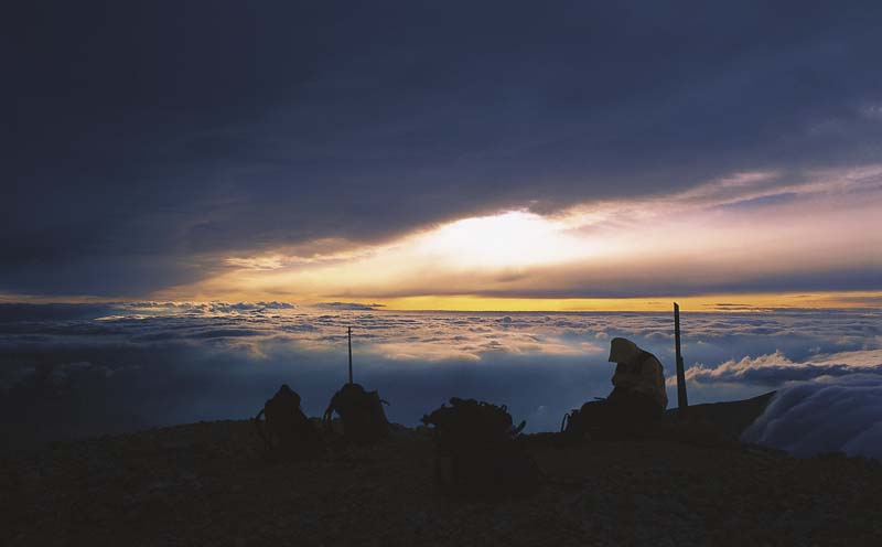 Aradan geçen yaklaşık on bir yıla, ülkenin başka bölgelerinde ve buralarda yapılan düzinelerce tırmanışa rağmen unutulmamış detaylar bunlar… Yıldız Teknik Üniversitesi Dağcılık Kulübü'nün kış temel eğitim kampı başlamak üzere. Hava soğuk, güneş parlıyor ve köy yüksek. Bizse hayatımızın ilk gerçek dağını görmüşüz, korku ve hayranlık birbirine karışıyor... Karşımızda, Aladağlar Silsilesi.
Niğde'den Kayseri'ye ve diğer ucu da Adana'ya varan etekleriyle yüzlerce kilometrekarelik bir alana yayılan dünyaca ünlü milli park; bir tırmanış bahçesi, önemli bitki bölgesi (ÖBB) ve kuş gözlem alanı. Dağa ulaşmak için Kayseri Havaalanı da tercih edilebilse de, tırmanışların başladığı merkezin Niğde olduğunu vurgulamak gerekir.
 Dağcılar açısından bölgenin temelde dörde ayrıldığı söylenebilir: Kuzey, Güney, Yedigöller ve Torasan. Bunlardan ilk üçü sıkça ziyaret edilen, en popüler zirveleri ve kaya duvarlarını barındıran yerler.
Tırmanış tecrübesi olan ve kendi organizasyonunu yapmak isteyen dağcılardan, yıllık izinlerini yükseklerde endemik türler ve sessizlik içinde geçirmek isteyen tatilcilere kadar uzanan geniş bir yelpazede, herkesin kendi macerasını yaratabileceği oldukça geniş ve ekolojik olarak hassas bir bölge Aladağlar. Sadece tırmanışla değil, bölgeleri birbirine bağlayan uzun yürüyüşleriyle de meşhur, bunlardan en önemlisi Niğde sınırlarından başlayıp Kayseri il sınırlarındaki Kapuzbaşı Şelaleleri'nde sona eren Trans Aladağlar yürüyüşü.
YERÇEKİMİNE KARŞI
Yıllar sonra yine buralara gelmek bir başka oluyor tabi, ömrün boyunca ziyaret ettiğin ve muhabbetine doyamadığın dostunun evine geliyor gibi gidiyorsun zirvelere, vadilere, boyunlara. Vadilerini sis etekleri kapatsa da sen gene de yürüyebiliyorsun nereye gittiğini bilerek, ama görmeden. İlk günlerdeki aç kalma ve üşüme korkusu yerini, daha hafif çantalar taşımak için çadırsız ve uyku tulumsuz tırmanışlar düzenleme fikrine bırakıyor. Artık saatlerce yatay uzanan yürüyüş rotalarından, sizi doğrudan yerçekimine karşı yükselten dikey rota planları yapılmaya başla
 nıyor. Onlarca kişiden oluşan eğitim toplulukları yerlerini iki-üç vefalı dosttan oluşan tırmanış ekiplerine bırakıyor. Aynı sessizliğin, aynı soğuğun ve aynı doruğun peşinde olmaktan mutlu, konuşmadan anlaşan dostlardan oluşan ekiplere.
DAĞA YAKLAŞIRKEN
Silsilenin yayılmış olduğu geniş coğrafya öncelikle rotanıza hangi vadi sistemlerini izleyerek çıkacağınıza karar vermenizi gerektiriyor.
Aladağlar'da rehber kitaplardan da tariflerini bulabileceğiniz yüzlerce rota olduğu gibi, bir o kadar; uzaklıkları ya da teknik zorlukları sebebiyle çıkılmamış rotalar da bulunuyor. Bölgenin 'tırmanış bahçesi' tanımlamasını hakkıyla taşıyor olmasının sebebi de işte bu... Buralarda, köylülerin traktörleriyle dağcıları tırmanışın başlayacağı noktalara taşımaları oldukça yaygın bir uygulama. Yaz aylarında kavurucu uzun toprak yollardan, kışın ise kuvvetli rüzgâra karşı karda bata çıka yapılacak yürüyüşleri ortadan kaldıran bu hizmet, dağcıların tırmanışları için harcayacakları enerji ve zamandan tasarruf etmelerini sağlıyor. Köylüler içinse günlük faaliyetleri dışında ufak da olsa bir ek kazanç demek.
ÇOK DAHA HAFİF OLMAK
Konfor için gerekli ve sizi sıcak tutacak malzemelerle birlikte, güvenli bir şekilde tırmanmanızı sağlayacak teknik malzemeleri aynı çantada buluşturduğunuzda, en az 25 kilo çeken bir yükten bahsedebiliriz. Yani bir katır kiralamanız ya da rotanızın dibine ulaşım için ayırdığınız süreyi iki katına çıkarmanız önerilebilir. İşte bu nedenle seneler ilerledikçe ve rotaların teknik zorluk dereceleri arttıkça daha küçük, daha hafif ve daha pahalı malzemelere g
 eçilir. Hatta hızı artırmak için bunların bazılarını taşımaktan vazgeçildiği bile olur. İleri seviyedeki teknik tırmanışlarda, kapladıkları yer ve ağırlıkları sebebiyle uyku tulumu ve çadır evde bırakılacaklar listesinde ilk sırada yer almaya başlar.
ZİRVEDEKİ UYKU
Uçaklara el sallamak, boşluk hissinin heyecanı, yüz kilometreler boyunca uzanan yalnızlık, başka hiçbir yerde duyulamayacak derinlikteki sessizlik, huzur arayışı, felsefe, böğürtlen toplamak, piknik veya yıllık izin… Dağda olmak için seçilebilecek sebeplerden sadece birkaçı. Her biri kendi içinde bir macera, her biri kişinin belki de kendi sınırlarını zorlayarak yaşadığı en büyük heyecanlardan. Peki ya uyumak? Ne dersiniz kendi başına bir macera olabilir mi?..
 Kulübe kayıt imzasını attığınız andan başlayan bir heyecandır dağcılık. Her defasında yeni bir yüzle karşınıza çıkan. Her defasında ilk defa gördüğünüz ve öğrendiğiniz bir şeyler barındıran. Tehlikeli bir macera değil sadece, binlerce kilometreyi sıfırlayan bir kültürel bağ. Yükseklere çıkanları ve çıkmayanları anlamanızı sağlayan. Bir kare fotoğraf için titreyerek zirvede uyumaktır...
Bu gezi yazısı, THY'nin Skylife dergisi Eylül 2007 tarihli sayısında yayımlanmıştır.
5 Şubat 2007 Pazartesi
Another Mardin: Dara
 Harboring a hitherto little known Mardin, the Dara ruins 30 km from Nusaybin continue to preserve their age-old secrets.
It’s impossible to stroll through the streets of Mardin and not be struck by the architecture and stone workmanship and the stories they tell. Yet after taking my fill of photographs of Mardin children, I decided to hit the road again. Thirty kilometers along the highway to Nusaybin I came upon the village of Oğuz. Putting aside my astonishment at how I’d missed Dara before as I drove on to more remote destinations, I have to admit I realized instantly that I was surrounded by an ancient Mardin inextricably intertwined with the village.
It was about to rain. The environs were quite dry and the pervasive tone was yellow. Children, village life, precisely cut stones and a Roman city all melded seamlessly into one another.
As I strolled among the domes, aqueducts and cisterns, an array of rock-cut tombs like those at Cappadocia, cave dwellings 8-10 meters in depth like those at Hasankeyf, and stone-carved figures and inscriptions in the walls appeared before me, whetting my curiosity and inspiring joy. Joy because it was at precisely that moment that I began to make the acquaintance of a different Mardin, in the Roman city of Dara - Anastasiopolis, dating back to the 6th century and so powerful that it was able to fend off invading armies.
MESOPOTAMIA’S FIRST DAM
The children of Dara had already fallen in in front of me to be my guides. This ancient city is known as the second most important border city, after the Southeastern metropolis of Nisibis (modern Nusaybin), of the Eastern Roman, or Byzantine, Empire. According to the sources, the Silk Road, that artery of international trade, ran through it. This capital of the transit trade was at one time even the seat of a bishopric until its importance waned following a period of incessant raids. Su sarnıçları, su depoları, bir su medeniyetine işaret ediyordu. Suyun akışını, oranını ya da bekletilmesini kontrol edebilen bir sistemin kalıntıları olan havuzlu salonu ve hendeği ile dwellings and churches with their ceiling decorations and walls carved with figures of Mary, Jesus and the cross tell the story of the city’s encounter with Christianity. But Dara played host to a number of religions in its various periods, and religious diversity also brought conflict in its wake - a situation in evidence even today and the reason why you can see elements of so many different religions all in one place here.Fragments of the city of Dara, which has been dubbed the Ephesus of Mesopotamia, have been used in the construction of the present-day village, which makes it difficult to arrive at clearcut data regarding the city.
THE EXCAVATIONS CONTINUE
In the book, ‘Mardin, Memory of Stone’, Prof. Metin Ahunbay, director of the Dara excavations, writes of the city: “The second largest ancient city in the province of ancient Mardin is Dara-Anastasiopolis, founded by the Roman emperor Anastasius and bearing his name. (Construction begun in 505 A.D.) The terrain is especially suitable for settlement: A large stream flows between the slopes of the valley in a north-south direction. A hill in the city’s northern sector is the spot most conducive to settlement; encircled by defense walls, Anastasiopolis - Dara is in the position of a ‘citadel’, and even today is known as the ‘Fortress Quarter’ of the village of Oğuz.” In the sources Dara is mentioned as a garrison town. Ahunbay says that the design of the city’s defense walls exhibits a similarity with the military architecture of Northern Syria in Late Antiquity and speaks of majestic three-storey towers where soldiers could be deployed to defend the city. Nonetheless little survives today of the city’s defense walls, which were the scene of great battles between the Romans and the Sasanians of Iran. The city has two gates, one opening in the direction of Nusaybin, which was an important commercial center in the period. Prof. Ahunbay gives information about the dam system and the trench that lay in front of this gate: “Special installations were built at the spots where the stream that ran through the city entered and exited. The arched openings in the walls allowed for the flow of water in both directions. Before it entered the city, the water at the river’s entrance was collected in a large pool. Through special sluices, it was then emptied into the trench from which it entered the city via canals.”
WHERE THE SOIL IS GOLD
As I continue to stroll through the city with the children of Dara, they show me some coins they’ve found left from the Roman period.Soon an elderly granny who lives in the village of Oğuz is trying to sell us a clay pot together with the soil in it, because she believes, or so she says, that this soil is gold. And perhaps she is not entirely unjustified. After all, we are in the middle of a magnificent Roman city that has been forgotten in time, on soil that is the color of pure gold.
This article was published in Turkish Airline's inflight magazine Skylife on February 2008.
With my thanks to Miss. Pekdemir due to her support in preparing the article while I was doing my military service.
Please view the Turkish translation of the article for photographs.
Bambaşka bir Mardin: Dara
Nusaybin’e 30 km. uzaklıktaki Dara Harabeleri, içinde pek de bilinmeyen bir Mardin’i saklıyor ve hâlâ sırlarını korumaya devam ediyor.Mardin’in sokaklarında dolaşıp taş işlemeciliğine, hikâyelerine, mimarisine hayran kalmamak mümkün değil ama, artık klişe Mardin fotoğraflarına hiç dokunmadan yola koyulmaya karar vermiştim. Nusaybin’e ulaşan otoyolun otuzuncu kilometresinde Oğuz Köyü’ne vardım. Daha uzaklara gitmeyi göze alıp, Dara’yı bugüne kadar es geçmiş olmanın şaşkınlığını bir kenara bırakacak olursam, köy ile iç içe geçmiş bir antik Mardin’in ortasında olduğumu hemen fark ettiğimi söyleyebilirim. Yağmur ha yağdı ha yağacak gibiydi. Hakim renk sarı ve etraf oldukça kuraktı… Çocuklar, köy hayatı, düzgün kesme taşlar ve bir Roma kenti birbiri içinde eriyordu... Kubbeler, kemerler, sarnıçlar arasında dolaşırken karşıma Kapadokya’dakilere benzer kaya mezarları, Hasankeyf’teki gibi 8-10 metre derinlikteki mağara evler, taş duvarlara işlenmiş figürler ya da yazıtlar çıkıyor; tümü merakımı ve sevincimi aynı oranda artırıyordu. Seviniyordum çünkü tam da o anda başka bir Mardin ile tanışmaya başlamıştım. Tarihi 6. yüzyıla inen, ordulara uzun süre direnebilecek güçteki Roma kenti Dara - Anastasiopolis ile…
MEZOPOTAMYA’NIN İLK BARAJI
 Daralı çocuklar rehberim olmak için çoktan önüme düşmüşlerdi. Antik kent, Doğu Roma’nın diğer deyişle Bizans’ın, Güneydoğu metropolü Nisibis’den (bugün Nusaybin) sonra ikinci önemli sınır kenti olarak biliniyor. Kaynaklara göre ticaretin kalbi İpek Yolu, kentin içinden geçiyordu. Bu transit ticaret merkezi, bir dönem piskoposluk merkezi de olmuş ancak sürekli devam eden akınlar sonrasında sönüp gitmişti. Kenti dolaşırken karşıma çıkan kalıntılar, bunu doğrularcasına izlerini gösteriyordu. Bilgilendirme tabelaları Dara’nın Mezopotamya’nın ilk barajının ve sulama kanallarının kurulduğu kent olduğunu yazıyordu. Bugün şaşırtıcı nizamıyla dikkat çeken kanallara ait izler yerli yerindeydi.
  Su sarnıçları, su depoları, bir su medeniyetine işaret ediyordu. Suyun akışını, oranını ya da bekletilmesini kontrol edebilen bir sistemin kalıntıları olan havuzlu salonu ve hendeği ile beraber... Oyma kaya evler, tavanlarındaki süslemeleri, duvarlarına işlenmiş Meryem, İsa ve haç figürleriyle kaya kiliselerine dönüşmüş yapılar kentin Hıristiyanlık macerasını anlatıyordu. Fakat Dara pek çok dine farklı zamanlarda ev sahipliği yapmıştı. Din çeşitliliği, beraberinde çatışmaları getirmişti. Bu durum da bugün farklı dinlere ait simgeleri bir arada görmemizin sebeplerinden biri olarak görünüyor. Mezopotamya’nın Efes’i olarak nitelenen Dara kentinin parçaları şu an varolan köyün inşasında kullanılmıştı. Ve bu yüzden kent hakkında net verilere ulaşmayı güçleştiriyordu.
KAZILAR DEVAM EDİYOR
Dara kazılarını yürüten Prof. Metin Ahunbay ‘Taşın Belleği Mardin’ adlı kitapta kent ile ilgili
 şunları yazar: “Antik Mardin ili içindeki ikinci büyük antik kent, Roma İmparatoru Anastasius’un kurdurduğu, aynı imparatorun adını da taşıyan Dara-Anastasiopolis’tir. (inşaatın başlangıcı 505 yılı)... Arazi yerleşme için çok elverişlidir: Kuzey-güney yönünde uzanan vadinin yamaçları arasında suyu bol bir dere bulunmaktadır. Kentin kuzey kesimindeki tepe, bir yerleşme için en uygun noktadır; surlarla çevrili Anastasiopolis - Dara’nın ‘sitadel’i anlamında bir konuma sahiptir. Nitekim günümüzde de Oğuz köyünün ‘Kale Mahallesi’ olarak anılır.”Dara bir garnizon kenti olarak geçiyor kaynaklarda. Ahunbay, Dara’nın kent suru tasarımının Geç Antik dönem Kuzey Suriye askeri mimarisiyle benzerlik gösterdiğini söylüyor ve asker yerleştirme imkânı da sağlayan heybetli üç katlı burçlardan söz ediyor. Sasani ve Roma’nın büyük savaşlarına sahne olan kentin surlarından günümüze ise pek bir şey kalmamış. Kentin iki kapısı varmış. Biri dönemin önemli ticaret merkezi Nusaybin’e açılıyormuş. Prof. Ahunbay bu kapının önündeki hendek ve baraj sistemi ile ilgili şunları bildiriyor: “Kentin ortasından geçen derenin
  giriş ve çıkışında özel düzenlemeler yapılmıştır. Her iki yönde de beden duvarlarına açılmış kemerli gedikler suyun akışına izin vermektedir. Dere girişi tarafında su, kente girmeden önce kanallarla büyük bir havuza toplanmaktadır, sonra özel düzenlenmiş oluklarla hendeğe boşaltılmakta, oradan kente giriş gerçekleşmektedir.”
“TOPRAK ALTINDIR”
Daralı çocuklar ile kent içinde dolaşmaya devam ederken, bana bulmuş oldukları Roma döneminden kalma sikkeleri gösteriyorlar. Az sonra Oğuz köyünde yaşayan teyze, toprağı ile beraber bir çömlek satmaya çalışıyor, çünkü toprak altınmış, öyle diyor, ona inanıyor... Haksız da değil belki. Altın renkli toprakların üzerinde, zaman içinde unutulmuş heybetli bir Roma kentinin ortasındayız ne de olsa...
Askerde olduğum dönemde yayımlanmış bu yazının hazırlanmasındaki katkıları için Bayan Pekdemir'e teşekkürü bir borç bilirim.
Bu makalenin redakte edilmiş hali, THY'nin dergisi Skylife dergisi Şubat 2007 tarihli sayısında yayımlanmıştır.
Please click to view English translation of the article above.
Kaydol:
Kayıtlar (Atom)